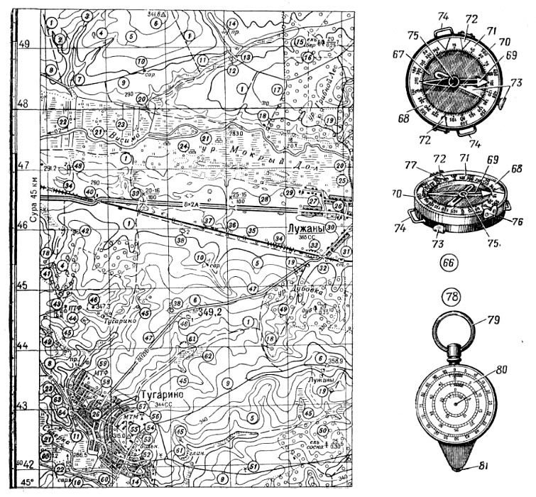
1-65 топографические условные знаки: 1 полевая [лесная] дорога, 2 овраг, 3 ручей, 4 отдельно стоящее дерево, 5 горизонталь, 6 геодезический пункт, 7 пруд или озеро, 8 улучшенная грунтовая дорога, 9 грунтовая [проселочная] дорога, 10 сарай, 11 проходимое травянистое болото, 12 водяная мельница, 13 проезжая плотина, 14 пруд с камышом, 15 смешанный лес, 16 просека (в лесу), 17 сухая канава, 18 колодец, 19 отдельно расположенные дворы, 20 мост, 21 река, 22 направление и скорость течения, 23 канавы, 24 торфоразработки, 25 гать, 26 населенный пункт, 27 улица [дорога] в населенном пункте, 28 автострада, 29 труднопроезжая дорога, 30 фруктовый сад, 31 железнодорожная станция, 32 путепровод над шоссейной дорогой, 33 выемка, 34 насыпь, 35 двухпутная железная дорога, 36 труба, 37 путевой пост, 38 курган, 39 путепровод под автострадой, 40 путепровод над автострадой, 41 низкорослый лес, 42 кустарник, 43 колодец с ветряным двигателем, 44 птицетоварная ферма, 45 родник, 46 высота, 47 шоссе, 48 яма, 49 лиственный (дубовый) лес, 50 хвойный лес, 51 ветряная мельница, 52 больница, 53 кладбище, 54 церковь, 55 склад горючего, 56 метеорологическая станция, 57 машинно-тракторная мастерская, 58 школа, 59 молочнотоварная ферма, 60 линия связи, 61 карьер, 62 заболоченный луг, 63 квартал в населенном пункте с огнестойкими постройками, 64 квартал в населенном пункте с неогнестойкими постройками, 65 ширина и глубина реки; 66-77 компас: 67 коробка, 68 алюминиевое кольцо с угломерной шкалой, 69 магнитная стрелка, 70 крышка, 71 стекло, 72 указатели в виде треугольников, 73 тормоз стрелки, 74 ушки для браслета, 75 шпенек, игла, 76-77 визирное приспособление: 76 прорезь, 77 мушка; 78-81 курвиметр: 79 кольцо, 80 циферблат, 81 колесико.
23. TOPOGRAPHIC MAP. COMPASS
1-65 topographical map symbols: 1 field or forest cart road [track] 2 ravine 3 brook stream 4 isolated tree (standing by itself) 5 contour 6 triangulation [trigonometrical] point 7 pond or lake 8 improved [stabilized] road 9 earth [country] road 10 shed, barn 11 swampy grassland [meadow] 12 watermill 13 dam and roadway 14 rushy pond 15 mixed wood [forest] 16 opening, cutting (in a forest) 17 dry ditch 18 well 19 isolated farm 20 bridge 21 river 22 flow direction and speed 23 ditches 24 peatery 25 corduroy road 26 inhabited [build-up] area 27 street [road] in an inhabited area 28 superhighway 29 unimproved [difficult] road 30 orchard 31 railway [railroad] station 32 overpass 33 cut 34 fill, levee 35 double-track(ed) line 36 culvert 37 lineman's cabin [box] 38 barrow 39 underpass 40 overpass 41 brushwood 42 bushes, shrubs 43 wind-driven well 44 poultry farm 45 spring 46 hill, eminence 47 highway 48 pit, hole 49 leaf-bearing (oak) wood [forest] 50 coniferous wood [forest] 51 windmill 52 hospital 53 cemetery 54 church 55 fuel storage 56 meteorological station 57 machine-and-tractor workshop 58 school 59 dairy farm 60 communication line 61 (barrow) pit 62 swampy meadow 63 block of houses with fireproof buildings 64 block of houses with nonfireproof buildings 65 river width and depth; 86-77 compass: 67 body 68 aluminum circle with azimuth scale 69 magnetic needle 70 lid 71 glass 72 triangalar indexes 73 needle lock(ing) pin 74 strap rings 75 free pivot 76-77 sights 76 rear sight 77 front sight; 78-81 curvometer: 79 ring 80 dial SI guide (wheel).
23. TOPOGRAPHISCHE KARTE. KOMPAfi
1-65 die Kartenzeichen n: 1 der Feldweg, der Waldweg 2 die Schlucht 3 der Bach 4 der Einzelbaum 5 die Horizontale 6 der geodatische Punkt 7 der Teich bzw. der See 8 der gebes-serte [unterhaltene] Weg 9 der nichterhaltene Fahrweg 10 der Schuppen, die Scheune 11 der passierbare Grassumpf 12 die Wassermiihle 13 der Fahrstaudamm 14 der Teich mit dem Schilf n 15 der Mischwald 16 die Schneise, der Waldsteg 17 der trockene Graben 18 der Brunnen 19 die einzeln angeordneten Hofe m 20 die Brflcke 21 der FluB 22 die Richtung und die Geschwindigkeit des FluBstromes m 23 die Graben m 24 der Torfbruch 25 der Faschinenweg, die FaschinenstraBe 26 die Sied-lung, die Ortschaft 27 die StraBe in der Siedlung I, die Sied-lungsstraBe 28 die Autobahn 29 die schwer passierbare [schwer fahrbare] StraBe 30 der Obstgarten 31 die Eisenbahnstation 32 die Chausseeiiberfiihrung 33 die Vertiefung 34 der Damm 35 das Doppelgleis 36 das DurchlaBrohr 37 der StraBenposten, der Wegeposten 38 das Hiigelgrab, das Htinengrab 39 die Auto-bahnunterftihrung 40 die Autobahniiberfiihrung 41 der Zwergwald 42 der Strauch, das Gestrauch 43 der Brunnen mit der Wind-stromanlage f 44 die Gefliigelfarm 45 die Quelle 46 die Hohe 47 die Chaussee 48 die Grube 49 der Laubwald, der Eichemval 50 der Nadelwald 51 die Windtniihle 52 das Krankenhaus 53 der Friedhof 54 die Kirche 55 das Brennstofflager, das Treibstoff-lager 56 die Wartestation 57 die Maschinen-Traktorenstation 58 die Schule 59 die Milchfarm 60 die Verbindungslinie 61 der Tagebau 62 die versumpfte Wiese 63 das Siedlungsviertel mit feuerfesten Bauten tn 64 das Siedlungsviertel mit nicht feuer-festen Bauten m 65 die FluBbreite und -tiefe; 66-77 der Kom-paB: 67 das Gehause 68 der Aluminiumteilring mit Stricheintei-lung f 69 die Magnetnadel 70 der Deckel 71 das Glas 72 die Dreieckanzeiger m 73 die Nadelbremse 74 die Armbandosen f 75 die Nadel 76-77 die Visiereinrichtung: 76 die Kimme 77 das Korn; 78-81 das Kurvimeter: 79 der Ringel 80 das Zifferblatt 81 das Radlein.
23. CARTE TOPOGRAPHIQLE. BOUSSOLE
1-65 les signes m conventionnaux topographiques: 1 le che-min de campagne f [de foret f] 2 le ravin 3 le ruisseau 4 1'ar-bre m isole 5 la ligne [la courbe] de niveau m 6 le point geode-sique 7 l'etang m ou le lac 8 le chemin de terre f ameliore 9 la charriere 10 la remise, l'hangar in 11 le marais herbeux praticable 12 le moulin a eau f 13 le barrage carrossable 14 l'etang m a Jonc tn 15 la foret mixte 16 la percee 17 le fosse sec 18 le puits 19 les fermes f isolees 20 le pont 21 la riviere 22 la direction et la Vitesse du fil m de la riviere 23 les fosses m 24 1'exploitation / de tourbe f 25 la chaussee en rondins tn 26 la localite 27 la rue [le chemin] dans la localite 28 l'auto-route f 29 le chemin defonce, la route labouree 30 le jardin fruitier 31 la gare, la station de chemin m de fer m 32 le viaduc au-dessus de la chaussee 33 le creux, le deblai 34 le remblai, le talus 35 le chemin de fer m a deux voies f 36 le tuyau, 1'aqueduc m 37 le poste routiere 38 le kourgane, le tertre 39 le viaduc audessous de l'autoroute f 40 le viaduc audessus de l'autoroute f 41 le bois clair 42 le buisson 43 le puits a moteur m a vent m 44 la ferme a volailles f 45 la sourse 46 le point, le piton 47 la grande route 48 la fosse 49 le bois feuillu [de la chenaie] 50 les coniferes in 51 le moulin a vent m 52 I'hdpital m 53 le cimetiere 54 1'eglise f 55 le depot de carbu-rants m 56 la station meteorologique 57 l'atelier m de machines I et de tracteurs m 58 l'ecole f 59 la ferme laitiere 60 la ligne de communication f [de liaison f] 61 la carriere 62 la prairie marecageuse 63 le quartier a batiments m ignifuges a 1'epreuve f du feu m 64 le quartier a batiments m non ignifuges a 1'epreuve f du leu in 65 la largeur et la profondeur de la riviere; 66-77 la boussole: 67 le boitier 68 le disque azimutal d'alumi-nium m 69 l'aiguille f aimantee 70 le couvercle 71 le verre 72 les indicateurs tn a triangle in de declinaison f 73 le frein de l'aiguille f 74 les oteilles f pour bracelet m 75 le pivot 76-77 le viseur: 76 la fente 77 le guidon; 78-81 le curvimetre: 79 i'anneau tn 80 l'echelle f 81 la roulette.
23. MAPA TOPOGRAFICO. BRUJULA
1-65 los signos convencionales topograficos: 1 el camino por campos m о bosques m 2 el barranco 3 el arroyo 4 an arbol independiente 5 la curva de nivel tn 6 el vertice geodesico 7 el estanque о el lago 8 el camino carretero f 9 el camino vecinal 10 el cobertizo 11 el pantano de hierba f pasadero 12 el molino de agua f 13 la presa coronada con camino m 14 el estanque con junco m 15 el bosque mezclado [compuesto] 16 la yereda (en el bosque) 17 la zanja seca 18 el pozo 19 las casas independientes 20 el puente 21 el rio 22 el sentido у velocidad f de corriente f 23 las zanjas 24 la turbera 25 el dique, el camino de troncos m 26 el pueblo, la poblacion 27 la calle [el camino] en un pueblo 28 la autopista 29 el camino de dificil acceso m 30 el huerto [la huerta] de arboles m frutales 31 la estacion [la parada] del ferrocarril 32 el viaducto (el paso por encima de la carretera) 33 el desmonte 34 el terraplen 35 el ferrocarril de doble via f 36 la alcantarilla 37 la garita de senales f 38 el tumulo 39 el viaducto (el paso bajo la autopista) 40 el viaducto (el paso por encima de la autopista) 41 el monte bajo 42 el matorral, la maleza 43 el pozo con motor tn de viento tn 44 la granja gallinera, el gallinero 45 el manantial, la fuente 46 la colina, la altura 47 la carretera 48 el hoyo 49 el bosque de arboles m de hoja f caediza (el robledo) 50 el pinar 51 el molino de viento m 52 el hospital 53 el cementerio 54 la iglesia 55 el deposito de combustible m 56 la estacion meteorologica 57 el taller de maquinaria m agricola 58 la escuela 59 la granja lechera, la vaqueria 60 la lfnea de comunicacion f 61 la cantera 62 el prado pantanoso 63 el barrio en el pueblo, con edificios tn incombustibles 64 el barrio en el pueblo, con edificios m simpli-ficados 65 la anchura у la profundidad del rio; 66-77 la brujula: 67 la caja 68 el anillo de aluminio m, con escala f goniometrica 69 la aguja magnetica 70 la tapa 71 el vidrio 72 los indicadores triangulares 73 el freno de la aguja 74 las orejetas para put sera f 75 la espiga; 76-77 el dispositive de visor m 76 la ra-nura, la mirilla 77 el punto de mira f 78-81 el curvfmetro: 79 el anillo 80 la escala 81 la ruedecilla.